In summary:
- Ottawa’s winter cycling success relies on mastering the prioritized, plowed network, not just on having the right gear.
- Key infrastructure like the Corktown Footbridge and separated bike lanes are “efficiency zones” that can make your winter commute faster and less stressful than driving or transit.
- Understanding seasonal intelligence, from pothole season in April to managing body heat at -20°C, is the key to comfort and safety.
- Connecting the urban network to recreational paths like the Greenbelt is possible even in winter, opening up year-round exploration.
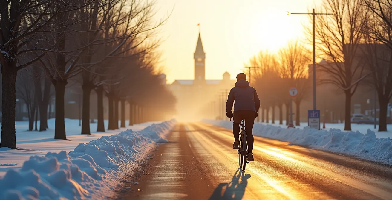
The first crisp Ottawa morning arrives, and with it, a familiar question for the dedicated cyclist: should the bike be put away for the winter? The fear of slipping on unseen ice, battling through unplowed snow, and arriving at work as a frozen statue is a powerful deterrent. Many guides will tell you the answer lies in expensive studded tires and complex layering systems. They treat winter as an enemy to be conquered with gear.
But what if the real key to year-round cycling in Ottawa isn’t about brute force, but about local knowledge and strategy? What if the city’s infrastructure holds secrets to not just surviving, but thriving on two wheels all winter? This guide shifts the perspective. We won’t just talk about what to buy; we’ll explore how to think. It’s about moving beyond fear and into a state of infrastructure mastery, where you understand the system of plowed routes, strategic shortcuts, and seasonal quirks that make Ottawa a surprisingly capable winter cycling city.
We’ll explore why some lanes are cleared before roads, how to use specific bridges to your advantage, and how biking can even be faster than the O-Train. We will also cover the non-obvious hazards of spring and the secrets to staying warm without overheating. Get ready to see your city’s cycling network in a whole new light.
Summary: How to Commute by Bike in Ottawa All Year Round?
- Why Are Some Bike Lanes Plowed Before the Roads?
- How to Use the Corktown Footbridge to Cut Your Commute Time?
- O-Train vs Bike: Which Is Faster from Westboro to Downtown?
- The Pothole Mistake That Ruins Your Bike Rims in April
- Where to Find Separated Lanes to Avoid Traffic Stress?
- How to Cycle From Downtown to Petrie Island on Protected Paths?
- How to Layer for a Run When It’s -20°C with Windchill?
- How to Explore Ottawa’s Greenbelt Trails Without a Car?
Why Are Some Bike Lanes Plowed Before the Roads?
It can feel like a surprising reversal of priorities, but seeing a bike lane cleared of snow while adjacent car lanes are still covered is a deliberate feature of Ottawa’s winter maintenance strategy. The city has established a Winter Cycling Network, a core system of routes designated for priority clearing. This network isn’t just an afterthought; it’s a critical transportation corridor for a growing number of year-round commuters. These routes receive higher service levels because they are often physically separated pathways or protected lanes that cannot be cleared by the same large plows used for main roads. They require specialized equipment and a dedicated schedule.
The goal is to provide a reliable and safe spine for active transportation throughout the winter. According to the City of Ottawa’s official data, this prioritized network covers over 60 kilometres of key commuting corridors. By focusing resources here, the city ensures that the most heavily used cycling routes remain functional, encouraging more people to choose their bikes even on snowy days. This strategy acknowledges that for many, cycling is not just recreation but essential daily transport. Knowing which routes are part of this network is the first step toward infrastructure mastery.
Your Action Plan: Reporting Unplowed Bike Lanes
- Call 3-1-1 or use the Ottawa 3-1-1 app to report the issue. This is the most direct way to log a service request.
- Provide the exact location, including the nearest intersection or a distinct landmark to help crews find the problem area quickly.
- Describe the specific problem: Is it ice buildup, a blockage from a snowbank, or debris left after plowing? Details matter.
- Include the time of day and explain how the condition affects your commute, adding context to the urgency of the report.
- If no action is taken within 48 hours, follow up on your request using the reference number provided to ensure it hasn’t been missed.
How to Use the Corktown Footbridge to Cut Your Commute Time?
The Adawe Crossing may get the spotlight, but for the savvy winter cyclist, the Corktown Footbridge is a true “efficiency zone.” This covered bridge connecting Centretown at Somerset Street with the University of Ottawa campus is a crucial link in the winter network. Its primary advantage is that it completely bypasses the unpredictable traffic and poor road conditions often found on the major vehicle bridges like Mackenzie King or Laurier. While drivers are stuck in congestion, a cyclist can glide over the Rideau Canal, protected from wind and precipitation.
The time savings are most significant during peak hours. A commute from the Glebe to the ByWard Market, for example, can be significantly shortened by using the canal pathways and crossing at Corktown. This route avoids dozens of traffic lights and the stress of navigating around cars and buses. The bridge itself is consistently maintained, and its covered nature means it is often free of the ice and snow that can accumulate on more exposed surfaces. Mastering your commute means identifying and linking together these key pieces of infrastructure to create a route that is not only safer but often dramatically faster than any alternative.
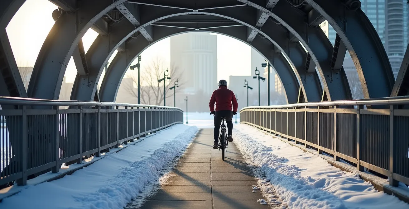
As you can see, the bridge offers a protected passage that is a stark contrast to the open environment around it. Using tools like the winter-maintained layers on Bike Ottawa Maps allows you to practice this kind of system navigation, planning routes that chain together prioritized paths, plowed bridges, and low-traffic streets to build the most efficient and lowest-stress commute possible.
O-Train vs Bike: Which Is Faster from Westboro to Downtown?
The automatic assumption is that public transit will always beat a bicycle in the depths of a Canadian winter. However, when you factor in the entire door-to-door journey—walking to the station, waiting for the train, potential delays, and walking to your final destination—the equation changes. For a common commute like Westboro to a downtown office near Parliament, a well-prepared cyclist can often match or even beat the O-Train’s time, especially when the LRT experiences service disruptions.
The key is a direct route. A cyclist can leverage the fully separated and priority-plowed Sir John A. Macdonald Parkway (SJAM) Pathway for a nearly uninterrupted ride. While the O-Train is fixed to its schedule and station locations, the cyclist has on-demand flexibility. This comparison isn’t just about the stopwatch; it’s about cost, health, and predictability. The monthly financial outlay for cycling is minimal compared to a PRESTO pass, and the built-in cardiovascular exercise is a benefit transit can’t offer. Let’s look at a direct comparison.
| Factor | O-Train (Winter) | Bike (Winter) |
|---|---|---|
| Door-to-door time | 25-30 minutes | 20-35 minutes |
| Cost per month | $128.75 (Presto Pass) | $15-30 (maintenance) |
| Weather dependency | Low | High |
| Exercise benefit | Minimal | 30-40 min cardio |
| Flexibility | Fixed schedule | On-demand |
This data highlights a nuanced reality. While the train offers reliability in extreme weather, the bike provides significant advantages in cost, health, and flexibility on most winter days. The decision ultimately comes down to personal priorities, but it’s clear that cycling remains a highly competitive option. This perspective is echoed by local experts who have mastered the winter commute. As Dr. Eugenie Waters, an Ottawa Hospital physician and year-round cyclist, notes in an article for The Ottawa Hospital Guide:
In the fair-weather months, Dr. Waters’ door-to-door commute is only five minutes longer on her bike compared to driving. In winter, she gives herself an extra five-minute head start. But the best route will always be the safest route.
– Dr. Eugenie Waters, The Ottawa Hospital Guide
The Pothole Mistake That Ruins Your Bike Rims in April
After navigating months of snow and ice, the biggest threat to your bike might just be the spring thaw. As temperatures fluctuate above and below freezing in March and April, the infamous Ottawa pothole season begins. For cyclists, these are not just bumps in the road; they are rim-destroying hazards. The most common mistake is assuming that the skills for riding on snow translate directly to navigating pockmarked asphalt. Riders often maintain lower tire pressure in winter for better grip on snow, but this practice can be disastrous when encountering a sharp-edged pothole, leading to a “pinch flat” or a permanently dented rim.
This is a perfect example of “seasonal intelligence.” The successful year-round cyclist adapts their equipment and riding style to the specific conditions of the month. As the snow melts, it’s crucial to increase tire pressure back to the recommended PSI for pavement. This creates a firmer tire that is more likely to roll over the edge of a pothole rather than compress and allow the rim to make direct, damaging contact. It’s also important to adjust your mindset. The fear of winter cycling is often overblown; an analysis of 384 winter cycling days shows roads are in excellent shape 88% of the time. The real, consistent danger is often the predictable result of the freeze-thaw cycle.
The key is vigilance. Scan the road surface farther ahead than you normally would, watch the lines of cars to see where they swerve, and be prepared to take the lane to avoid a particularly bad patch. A ruined rim is an expensive and frustrating end to what should be a triumphant return to spring riding.
Where to Find Separated Lanes to Avoid Traffic Stress?
One of the biggest sources of anxiety for any urban cyclist, especially in winter, is the stress of riding in mixed traffic. Painted bike lanes offer a visual suggestion of space, but they provide zero physical protection and often disappear under snowbanks or become blocked by illegally parked vehicles. For a truly low-stress commute, the goal is to maximize time spent on physically separated infrastructure. In Ottawa, this means seeking out protected bike lanes and multi-use pathways that create a genuine barrier between you and motor vehicles.
Key corridors like the O’Connor Street Bikeway, the Main Street Renewal project, and sections of the Confederation Boulevard pathway provide this crucial separation. These are the arteries of a low-stress winter network. They are not only safer but are also often part of the priority plowing schedule, making them more reliable. The advocacy for more of this type of infrastructure is growing, with many looking to other Canadian cities as a model. For instance, Montreal, a city with a similar climate, is aggressively expanding its winter-cleared network with a focus on physical separation. This isn’t just a nice-to-have; it’s a fundamental principle of safe and inviting winter city design.
As cycling advocate Dave Shellnutt explains in a report for Bike Ottawa, the solution is often simple and logical:
Painted lanes notoriously disappear in every city during winter when they are used for snow storage and snow banks force parked cars into the painted lanes. The simple solution is to shift car parking to the outside near live car traffic and place people on bikes next to the curb, separated with quick-build barriers.
– Dave Shellnutt, Bike Ottawa Report
This principle of “protection over paint” is the core of a stress-free commute. By planning your route to link these separated sections, you can significantly reduce your cognitive load and simply enjoy the ride.
How to Cycle From Downtown to Petrie Island on Protected Paths?
While commuting is a primary focus for many winter cyclists, the network also opens up incredible recreational opportunities. A fantastic example is the ride from the downtown core to Petrie Island in the east end. This journey, which might seem daunting, can be accomplished almost entirely on protected multi-use pathways along the Ottawa River. This route showcases the impressive scale of the National Capital Commission’s Capital Pathway network, which is a jewel of the city’s active transportation system.
The journey starts by connecting to the Ottawa River Pathway behind Parliament Hill and heading east. This scenic path winds along the river, passing Rockcliffe Park and the Canada Aviation and Space Museum. The path is generally wide and, in many key sections, receives winter maintenance. It provides a stunning, nature-filled ride that feels worlds away from the city’s hustle. The Capital Pathway is one of the most extensive in North America, with over 200 kilometres of off-road pathways linking parks, museums, and natural areas.
However, “seasonal intelligence” is critical for a successful recreational ride in winter. While the path itself may be clear, you must be self-sufficient. Key amenities are seasonal. This means you should expect that:
- NCC washrooms along the route are almost all closed, typically from mid-October until May.
- Drinking fountains are turned off to prevent freezing pipes. You must carry all the water you will need.
- Pathway patrollers are a summer service; you will be on your own for directions and basic repairs.
Despite these considerations, the ability to cycle from the urban heart of the city to a natural beach environment like Petrie Island on a crisp winter day is a unique Ottawa experience that is well worth the preparation.
How to Layer for a Run When It’s -20°C with Windchill?
While the title mentions running, the principles of thermal regulation are even more critical for cycling at cold temperatures. The biggest mistake beginners make is overdressing. A cyclist generates a tremendous amount of body heat, and the challenge is not just staying warm, but managing sweat. A damp base layer is the fastest way to get dangerously cold. The fear of a -20°C windchill leads people to put on their heaviest parkas, only to be soaked and freezing within 15 minutes. In reality, the average winter day in Ottawa is a very manageable -4°C.
The secret is “micro-climate management.” You need to create a layering system that you can adjust on the fly to vent heat and moisture. The core principle is known among experienced winter cyclists as the 10-Minute Cold Rule. It’s a counter-intuitive approach that requires a little faith but pays huge dividends in comfort.
- Start slightly cold: You should feel a bit chilly for the first 5-10 minutes of your ride. If you are perfectly warm when you step out the door, you are overdressed.
- Warm up gradually: Trust your body. It is a powerful furnace. As you start pedaling, your internal temperature will rise, and you will quickly become comfortable.
- Avoid overdressing: The primary challenge is to keep from overheating and sweating. Sweat is your enemy because it makes your clothing wet, which then rapidly chills you when you stop or slow down.
- Manage airflow: Your layering system should include zippers at the neck, pits, and chest. These are your thermostats. Unzip as you warm up to let heat and moisture escape, and zip up on long descents or when facing a strong headwind.
- Adjust en route: Don’t be afraid to stop and remove a layer if you feel yourself starting to sweat. It’s better to take 60 seconds to adjust than to spend the rest of your ride in a dangerously damp state.
This approach, focusing on a breathable base layer, an insulating mid-layer, and a windproof/water-resistant outer shell with lots of vents, is the key to comfort at any temperature.
Key takeaways
- Winter cycling in Ottawa is less about gear and more about mastering the city’s maintained infrastructure and local knowledge.
- Physically separated bike lanes are the gold standard for low-stress winter commuting, as painted lanes often become unusable.
- Effective layering means starting your ride slightly cold to prevent overheating and managing sweat, which is the real danger in cold weather.
How to Explore Ottawa’s Greenbelt Trails Without a Car?
The beauty of Ottawa’s cycling network is its ability to connect the dense urban core with the vast natural expanse of the Greenbelt. You do not need a car to access these beautiful trails for a day of winter exploration. The Capital Pathway network acts as the bridge, allowing a cyclist to ride from their downtown apartment directly to a trailhead in a protected forest or conservation area. This “bike-to-trailhead” approach transforms the bicycle into a tool for genuine adventure.
Routes like the Greenbelt Pathway West and East are designed to link residential areas with these natural spaces. For example, a cyclist can use the city’s pathway system to connect to Shirleys Bay, where trails offer stunning winter scenery and opportunities for fat biking or cross-country skiing. The network is designed to be a series of discovery routes, seamlessly transitioning from city centre, through suburbs, and out into wooded, rural-feeling areas. This connectivity is what makes Ottawa’s year-round cycling potential so unique.
Successfully planning these trips requires a bit of system navigation. It means using online maps to trace a route from the winter-maintained urban network to the Greenbelt trails, which may have different conditions. Some Greenbelt trails are groomed for skiing or shared use, while others might be singletrack best suited for a fat bike. Doing your research on the specific trail conditions before you go is part of the adventure. It’s the ultimate expression of infrastructure mastery: using the entire, interconnected system for both utilitarian commuting and soul-filling recreation, 365 days a year.
Your year-round cycling journey starts with that first strategic ride. Armed with this local knowledge, you can move past the fear of the elements and start seeing the winter landscape as a new world to explore. So, check the city’s pathway maps, dress for micro-climate management, and discover the profound freedom of winter commuting in Ottawa.