Leisure and Outings
Ottawa’s unique position as Canada’s capital creates an exceptional landscape for leisure and outdoor recreation. The city’s identity is deeply intertwined with its natural assets: the National Capital Commission (NCC) manages over 361 square kilometres of green space, creating an interconnected network of parks, trails, and waterways that few other urban centres can match. Whether you’re seeking a quiet afternoon in a hidden city park or planning an ambitious cycling route along the Ottawa River, understanding how these recreational spaces function throughout the seasons transforms occasional visits into confident, rewarding experiences.
For residents and visitors alike, navigating Ottawa’s leisure opportunities requires more than simply knowing where parks exist. The capital’s recreational infrastructure operates under specific regulations, presents distinct seasonal characteristics, and offers varying levels of accessibility depending on your experience and preparation. This comprehensive resource introduces the foundational elements of Ottawa’s outdoor leisure landscape, from the Greenbelt’s trail systems to the world-renowned Rideau Canal Skateway, helping you make informed decisions about where, when, and how to maximize your time outdoors.
Accessing Nature Within Urban Boundaries: The Greenbelt System
The Greenbelt represents one of Ottawa’s most distinctive features—a 20,350-hectare conservation area that encircles the urban core, creating a permanent buffer between city development and rural landscapes. Established in the 1950s through federal acquisition of agricultural land, this green belt wasn’t designed as a traditional park but rather as a multifunctional landscape that preserves natural habitats, supports research facilities, and provides public recreation opportunities.
Understanding the Greenbelt’s Unique Design Philosophy
Unlike municipal parks designed specifically for recreation, the Greenbelt follows an integrated land-use model. Approximately 25% of the area remains actively farmed through agricultural leases, while designated conservation zones protect sensitive ecosystems like wetlands and mature forests. For recreational users, this means access points and trail systems are strategically distributed rather than uniformly available. Popular sectors like Mer Bleue Bog, Pine Grove Forest, and Stony Swamp each offer distinct natural experiences, from raised boardwalks through peatlands to technical single-track mountain biking trails.
Choosing the Right Nature Experience for Your Skill Level
The Greenbelt’s recreational offerings span a wide difficulty spectrum. Beginners often gravitate toward interpreted trails like the Mer Bleue boardwalk, where a 1.2-kilometre loop provides accessible views of a rare boreal ecosystem without requiring specialized footwear or navigation skills. Intermediate users might tackle the longer trails at Stony Swamp, where interconnected loops allow for customized distances ranging from 3 to 12 kilometres. Advanced outdoor enthusiasts frequently explore the more remote sectors where trail maintenance is minimal and orienteering skills become valuable.
Seasonal Considerations and Wildlife Safety
Timing your Greenbelt visit requires understanding Ottawa’s pronounced seasonal shifts. Spring conditions (March through May) present muddy, often impassable trails as freeze-thaw cycles break down surfaces—many sectors actually close trails during this period to prevent erosion. Autumn offers peak conditions with stable footing and spectacular foliage, but also coincides with hunting season in designated areas; checking NCC closure notices before visiting remote sectors is essential. Wildlife encounters, particularly with coyotes and black bears in outlying areas, require basic precautions: making noise on blind corners, keeping dogs leashed, and avoiding dawn/dusk visits during berry season when bears are most active.
Waterways as Recreational Corridors: River and Canal Activities
Ottawa’s position at the confluence of three major waterways—the Ottawa River, Rideau River, and Rideau Canal—creates exceptional opportunities for water-based recreation. Each waterway offers distinct characteristics shaped by historical use, current management, and seasonal accessibility.
The Ottawa River: From Historical Trade Routes to Modern Recreation
The Ottawa River served as the primary transportation corridor for the fur trade and later the timber industry, roles that shaped the shoreline infrastructure still visible today. Modern recreational users benefit from this legacy through established put-in points, shoreline parks, and the pathway network that follows historical portage routes. The river’s scale—averaging 1.5 kilometres wide near the downtown core—demands respect. Paddlers must understand current patterns, particularly near the Chaudière Falls area where historical navigation channels create complex water movements.
Navigating the Canal System and Lock Operations
The Rideau Canal operates as a functioning historical waterway, meaning recreational boaters share the locks with Parks Canada’s heritage preservation mandate. The eight locks within Ottawa’s boundaries operate on a first-come, first-served basis during the navigation season (typically mid-May through mid-October), with lockages taking approximately 20-45 minutes depending on boat traffic. Understanding the lock etiquette—approaching slowly, having lines ready, following lockmaster instructions—prevents delays and ensures safe passage. Non-motorized craft like kayaks and canoes can often lock through free of charge, though registration requirements apply.
Comparing Water Experience Options
Choosing between river and canal paddling depends on your objectives. The Ottawa River offers expansive views, connection to wilderness areas upstream, and opportunities for longer-distance touring, but requires stronger paddling skills and awareness of motorized boat traffic. The Rideau Canal provides a more controlled environment with predictable conditions, historic lockstations as rest points, and urban accessibility, though the experience is inherently more structured. Sunset cruises—whether self-powered or aboard commercial tour boats—represent a third option, with the golden hour light transforming familiar shorelines into memorable vistas.
Urban Parks: Maximizing City Green Space Opportunities
Beyond the Greenbelt’s wilderness character and waterway corridors, Ottawa maintains over 900 individual parks ranging from neighbourhood tot lots to significant urban green spaces like Commissioners Park and Hog’s Back Park. These spaces operate under municipal bylaws that differ from NCC-managed lands, creating a regulatory landscape that rewards understanding.
Understanding Park Regulations and Permit Requirements
City of Ottawa parks follow specific use regulations that govern activities from alcohol consumption (prohibited except in designated picnic areas with permits) to amplified music (requiring special event permits for gatherings over 25 people). Dog regulations vary by park designation: some offer fully fenced off-leash areas, others allow off-leash use during specific hours (typically before 10 AM and after 6 PM), while sensitive natural areas require leashing at all times. The fine structure for violations ranges from $75 for minor infractions to $305 for significant breaches, making advance research worthwhile.
Finding Hidden Facilities and Recreational Features
Many urban parks contain facilities that aren’t immediately obvious to first-time visitors. Andrew Haydon Park, for example, includes not only waterfront beaches and picnic areas but also seasonal kayak rentals, beach volleyball courts, and designated fishing areas. Bruce Pit—a former gravel quarry—functions as one of the city’s most popular off-leash dog areas while simultaneously supporting community gardens and informal trail networks. Learning to identify these multi-use features helps you select parks that align with specific recreational goals rather than defaulting to the most well-known options.
Seasonal Optimization and Parking Strategies
Urban park visitation follows predictable seasonal patterns. Summer weekends see major waterfront parks reaching capacity by mid-morning, particularly during festival periods like Bluesfest or Winterlude. Strategic timing—visiting on weekday afternoons or during shoulder seasons—provides dramatically different experiences. Parking enforcement in popular parks is consistent; understanding which lots require payment (typically $4-8 daily), which accept only municipal parking passes, and which offer free access after certain hours prevents the frustration of returning to a ticketed vehicle.
The NCC Pathway Network: Active Transportation and Recreation
The National Capital Commission maintains over 600 kilometres of multi-use pathways connecting parks, neighbourhoods, and regional destinations. This network functions simultaneously as recreational infrastructure and active transportation corridor, creating a shared-use environment that requires understanding pathway etiquette and navigation principles.
Pathway Etiquette and User Hierarchy
NCC pathways follow a “wheels yield to heels” principle where faster users bear responsibility for safe passing. Cyclists should audibly signal (“on your left”) well before overtaking, reduce speed in congested areas, and use bells rather than shouting. Pedestrians should maintain awareness by walking single-file on busier sections and keeping pets on short leashes to prevent tripping hazards. Inline skaters and skateboard users should maintain predictable lines and avoid sudden directional changes. During peak commuting hours (7-9 AM and 4-6 PM on weekdays), recreational users should anticipate higher speeds and denser traffic as the pathways serve their transportation function.
Planning Long-Distance Routes and Comparing River Sides
The pathway network enables substantial recreational journeys. The Ottawa River pathway extends roughly 35 kilometres from Andrew Haydon Park in the west to Petrie Island in the east, while the Rideau Canal pathway connects the Hartwells Locks to Dow’s Lake over approximately 8 kilometres. Comparing the “Quebec side” versus “Ontario side” of the Ottawa River pathways reveals distinct characteristics: the northern pathways (Voyageurs, Gatineau Park approaches) offer more elevation changes and closer connections to wilderness, while the southern pathways provide better urban amenities, rest facilities, and weather protection.
Seasonal Hazards and Optimizing Rest Stops
Pathway conditions vary dramatically by season. Spring presents frost heave damage and flooding in low-lying sections near the river. Autumn brings leaf cover that obscures pathway edges and creates slippery conditions when wet. Winter pathway use (on sections not converted to skating) requires studded tires or cleats for safe navigation. Planning routes around known rest facilities—locations with public washrooms, water fountains (seasonal), and shelter—becomes essential for journeys exceeding 10 kilometres. Popular rest points include Remic Rapids, Dow’s Lake Pavilion, and the Canada Aviation and Space Museum parking area.
Winter’s Signature Experience: The Rideau Canal Skateway
The transformation of the Rideau Canal into the world’s largest naturally frozen skating rink represents Ottawa’s most internationally recognized recreational feature. Operating typically from January through early March (conditions permitting), the 7.8-kilometre skateway attracts over one million visits during an average season.
Understanding Ice Formation Science and Opening Conditions
The Skateway doesn’t simply freeze naturally and open; NCC ice crews actively manage the process. Ideal formation requires sustained temperatures below -10°C for approximately two weeks without significant snowfall (snow acts as insulation, slowing ice thickening). Crews flood and resurface sections, monitor thickness continuously, and make opening decisions sector-by-sector. This means the Skateway rarely opens its entire length simultaneously—downtown sections typically freeze first, while Dow’s Lake freezes last due to water depth variations. Checking the NCC’s ice conditions updates before visiting prevents arriving to closed sections.
Equipment Rental Efficiency and Entry Point Selection
Several entry points offer skate rentals, but efficiency varies significantly. Fifth Avenue and Dow’s Lake Pavilion maintain the largest rental inventories with shortest wait times, while smaller pavilions like NAC (National Arts Centre) and Patterson Creek may experience inventory shortages during peak weekend periods. Rental costs typically run $20 for adults, $16 for youth, with helmet rentals included. Bringing your own skates allows entry at any access point—there are 22 maintained access points along the length, though only 8 have full facilities (washrooms, warming areas, concessions).
Safety Hazards and Optimizing the BeaverTails Stop
Skateway safety risks differ from arena skating. Ice thickness varies across the width; staying within marked boundaries prevents weak ice areas. Sections near locks and bridges present rough ice from water currents underneath. Weather significantly impacts ice quality—freeze-thaw cycles create dangerous conditions, and the NCC closes sections or the entire Skateway when temperatures approach 0°C. Planning your skate to include a BeaverTails stop (the iconic fried pastry available at multiple pavilions) requires strategy: Fifth Avenue and Dow’s Lake have longest lines mid-afternoon on weekends, while early morning or evening visits significantly reduce wait times without sacrificing the experience.
Trail Selection: Matching Difficulty to Experience Level
Ottawa’s surrounding region offers hiking trails ranging from barrier-free interpretive paths to challenging escarpment climbs in nearby Gatineau Park. Understanding trail rating systems and matching them to your fitness level and experience ensures enjoyable rather than frustrating outings.
Decoding Trail Difficulty Ratings
Trail ratings in the National Capital Region generally follow a three-tier system: easy (green), intermediate (blue), and difficult (black). However, these ratings reflect different factors depending on the managing organization. NCC trails rate primarily on distance and surface quality, while Gatineau Park trails incorporate elevation gain and technical challenges. A “difficult” rating might indicate either a 12-kilometre length on gentle terrain or a 5-kilometre route with 300 metres of elevation gain—understanding which factor drives the rating prevents mismatched expectations.
Scenic Lookouts and Seasonal Gear Optimization
The region’s most rewarding vistas require strategic timing. Champlain Lookout in Gatineau Park offers panoramic views over the Ottawa Valley, but autumn weekends see parking lots full by 9 AM. King Mountain provides similar vistas with less crowding. Seasonal gear choices dramatically impact comfort: spring hiking demands waterproof boots and gaiters for mud management, summer requires sun protection and hydration systems for exposed ridges, autumn needs layering systems for variable temperatures, and late-season hiking requires traction aids like microspikes as trails develop ice patches.
Practical Considerations: Parking and Tick Prevention
Trailhead parking in Gatineau Park requires either a daily pass ($12.25) or annual access pass, with payment enforced year-round. Popular trails like Lusk Cave and King Mountain Trail see regular parking violations tickets ($100+). Tick awareness has become increasingly important as blacklegged ticks (which can carry Lyme disease) have established populations in the region. Prevention strategies include staying on cleared trails, wearing light-coloured clothing for easy tick spotting, tucking pants into socks, applying DEET-based repellents to clothing, and performing thorough tick checks after hiking—particularly in long grass areas during May through July when nymphs are most active.
Ottawa’s leisure and outdoor opportunities reward preparation and local knowledge. From understanding the Greenbelt’s seasonal access patterns to timing your Skateway visit around ice conditions and crowd levels, each recreational pursuit benefits from moving beyond basic awareness to informed planning. The resources outlined here provide foundational knowledge, but each topic—whether canal navigation, pathway route planning, or trail selection—offers depth worth exploring further based on your specific interests and skill development goals.

Which Gatineau Park Trail Offers the Best View for Minimal Effort?
The best Gatineau Park view isn’t found on the most difficult trail, but through local knowledge of timing, access, and true effort. Trail ratings can be deceptive; a “moderate” trail’s elevation gain can be more challenging than a “long” trail’s…
Read more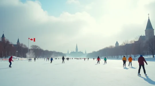
Skating the Rideau Canal on a ‘Green’ Day: Your Official Planning Guide
A green flag on the Rideau Canal Skateway is a license to skate, not a guarantee of perfect ice; true mastery lies in understanding the rink’s micro-climates and operational rhythms. Ice quality varies significantly, with areas under bridges and in…
Read more
Mastering Ottawa’s Pathways: A Rule-Based Guide to Never Getting Lost
In summary: Mastering Ottawa’s pathways requires knowing both official rules, like mandatory bell use, and unwritten local protocols. Seasonal hazards are predictable; spring flooding and lingering ice patches require specific detour and equipment strategies. True efficiency comes from integrating your…
Read more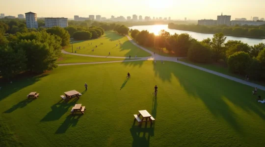
Which Ottawa Park Offers the Best Amenities for a Full Day Out?
The best park for your group outing in Ottawa depends less on location and more on understanding the city’s operational logic for its amenities. Amenity availability (like BBQs and washrooms) is governed by specific safety regulations, seasonal schedules, and municipal…
Read more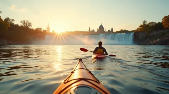
How to Truly See Rideau Falls: An Insider’s Guide to Kayaking Ottawa’s Waterways
Seeing Rideau Falls from a kayak is more than just a rental; it’s about mastering Ottawa’s unique waterways with skill and confidence. Success depends on strategic navigation, understanding the difference between the river and the canal, and choosing the right…
Read more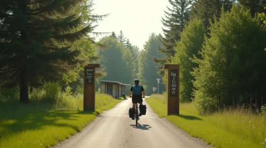
Your Car-Free Guide to Exploring Ottawa’s Greenbelt Trails
Accessing Ottawa’s Greenbelt without a car is not a limitation; it’s an opportunity for a more intentional and rewarding nature experience. The Greenbelt’s unique design and a growing network of pathways and transit options make it surprisingly accessible from the…
Read more